

Round one of a three-storm sequence continues spreading snow across the Northern Tier, moving into the Northeast by Sunday morning. The system will bring snow, freezing rain, and ice, impacting the Midwest, Northeast, and Mid-Atlantic through Wednesday. Stay tuned to FOX Weather for the latest updates.
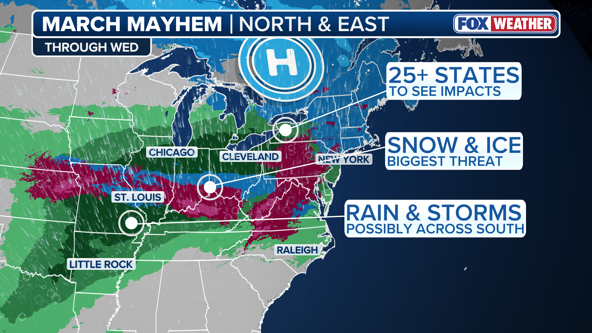
Round one of a three-storm sequence kicked off this weekend and is continuing to spread snow across the Northern Tier, launching a multi-day stretch that will impact millions across more than 25 states in the winter-weary Midwest and Northeast with snow and ice.
(FOX Weather)
This first wave is making its way to the Northeast this morning, followed by a second system — Sunday through Monday — starting in the Midwest and impacting the Mid-Atlantic by Monday, with the final wave arriving on Tuesday, primarily focusing on the Northeast and Mid-Atlantic.
Winter Weather Alerts have been issued for parts of Nebraska, Missouri and Kansas through Monday morning; however, these storms will not be as impactful as the historic blizzard that slammed the Interstate 95 corridor earlier last week.
Round 1—through midday Sunday: Snow moves across Northern Tier
A brief surge of arctic air is moving east across the Northern Tier, accompanied by a strong arctic high that continues to affect the region.
Snow accumulations from this fast-moving system are expected to remain under 3 inches as the cold air and snow will reach the Northeast later Sunday morning.

(FOX Weather)
The FOX Forecast Center said highs will struggle to climb out of the 30s during the day, with readings dropping into the 20s by Sunday night and Monday morning, and wind chills along the I-95 corridor potentially falling into the single digits.
WHAT DOES THE WIND CHILL MEAN?
Some accumulating snow is possible in cities such as New York, Providence and Boston, but lighter snow rates are expected to keep totals under 2 inches.
Snow in the Dakotas exceeded expectations Saturday, with numerous reports of 5 to 8 inches. Bismarck Airport recorded 5.4 inches for the event.
In Minnesota, Preston reported 10 inches, with a “bullseye” of snow totals between 8 and 10 inches observed south of I-90, between Rochester, Minnesota, and La Crosse, Wisconsin.
Notably, one report indicated 5.5 inches of snow that melted down to 0.16 inches of liquid water, and according to National Weather Service officials, this would suggest an unusually high snow-to-liquid ratio of approximately 34:1 if confirmed.
Overall, snow ratios from this event were significantly underestimated by forecast models, resulting in higher-than-expected accumulations over a short period, the FOX Forecast Center said.
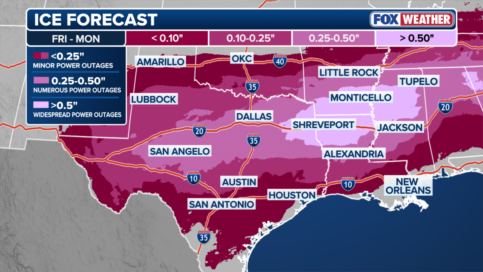
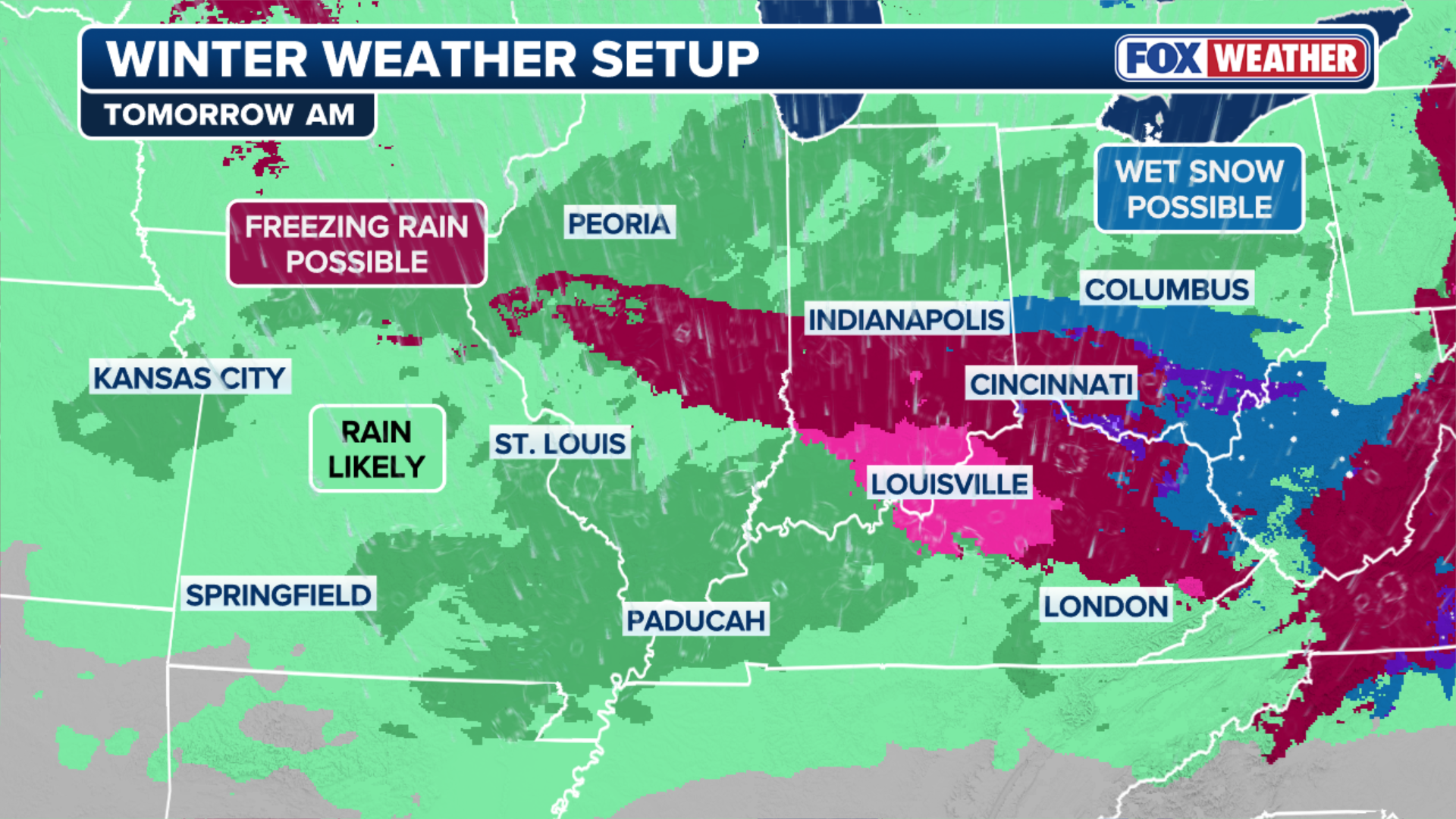
Round 2–Sunday afternoon through Monday: Snow, freezing rain, ice enters Midwest, Ohio Valley
Just as the first wave ends in the Northeast, a second system will develop along the tail end of the passing cold front.
Warmer, moist air from the Gulf will be pulled north by southerly winds and ride up over the front. This sets up a process known as overrunning, where warm, moist air rises up and over dense, cold air locked in at the surface.
(FOX Weather)
According to the FOX Forecast Center, the region to watch late Sunday includes parts of the Heartland and Midwest.
Snow and freezing rain are likely to begin in Nebraska, Kansas and Missouri between 3 and 6 p.m. CT.
With temperatures in these areas expected to hover near freezing, it will lead to a sharp transition from rain to freezing rain and then to snow, with St. Louis, Kansas City, Louisville, Indianapolis, and Cincinnati all at risk of at least some freezing rain.
(FOX Weather)
Snow totals for this round are expected to be modest, around 1 to 3 inches, representing one of the lower-end scenarios considered in recent forecasts.
SNOW MELTERS: WHAT ARE THEY AND HOW DO THEY WORK?
Ice accumulations will likely be limited to a light glaze or up to 0.10 inches, as rain is expected to overtake areas seeing freezing rain, quickly melting any ice and snow, with Winter Weather Alerts issued for parts of Nebraska, Missouri and Kansas.

(FOX Weather)
On Monday, snow and ice may shift into the Mid-Atlantic, but uncertainty remains.
Some forecast models indicate a burst of heavier snow in the Virginias and in Maryland, while others show little to no moisture, resulting in mostly calm conditions, and if snow does occur, totals could reach up to 3 inches in areas such as Roanoke and possibly Richmond.
DOZENS OF HEAT RECORDS BROKEN ACROSS SOUTHWEST AS MIDWEST, NORTHEAST PREPARE FOR MORE SNOW
Washington, D.C., could see minor snow, but amounts are expected to be minimal.
Lastly, the FOX Forecast Center is monitoring northern Kentucky and Ohio before a possible early Monday winter weather event.
Forecast models suggest a brief period of wintry weather prior to sunrise, potentially affecting cities including Lexington, KY, and Cincinnati.
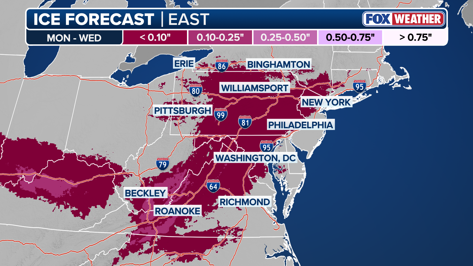
Round 3 –Tuesday through Wednesday morning: Rain with threats of snow and ice move Northeast
The third round will arrive on Tuesday as moisture-laden air is funneled from the south, caught between high pressure exiting off the eastern seaboard and a developing low-pressure system in the Plains.
While the majority of the precipitation will be rain, the air should remain just cold enough across parts of the Midwest to the Northeast to trigger the development of ice and snow, with the best chance for accumulating snow remaining north of I-90.
HOW HIGH PRESSURE AND LOW PRESSURE DRIVE THE WEATHER
While below-freezing air will stay trapped in the valleys, significant icing will be a concern across Pennsylvania, with some cold air damming possibly making freezing rain a concern in Virginia and North Carolina.
This round has potential ice totals in the 0.10 to 0.25-inch range due to a higher confidence of prolonged, colder air mass at the surface.
(FOX Weather)
According to the FOX Forecast Center, depending on how strong the southerly push of “warmer” air aloft will be, it will determine the threat across the North.
A stronger surge will allow for less snow, and an even greater coverage of freezing rain.
Currently, snow threats look to be in Upstate New York, Connecticut, Rhode Island, Massachusetts and northward.
Totals from this round could be up to 6 inches through Wednesday, but the highest totals would likely be at higher elevations, and the snow would likely be overtaken by rain by the end of the event.

(FOX Weather)
For bigger I-95 cities, New York City, Philadelphia, Baltimore and Washington DC would be on the fringe of snow, ice and rain, with Boston having the greatest chance of being in a longer stretch of snow.